Unmanned aerial vehicles aren't just for spying on militants or taking out bad guys in terrorist hotspots like Fallujah or Aleppo anymore.
Commercial real estate developers, designers, engineers, brokers and marketers are increasingly relying on drones with high-resolution cameras attached to remotely survey land, envision what a building would look like or sell space to tenants or buyers.
Little wonder. Unmanned aerial vehicles, or UAVs, have proven themselves to be versatile and less expensive than traditional methods of capturing real estate images. With recent digital technological advancements, too, proponents say pictures and video turn out clearer and contain more detail than almost anything snapped by a handheld camera from a helicopter or airplane.
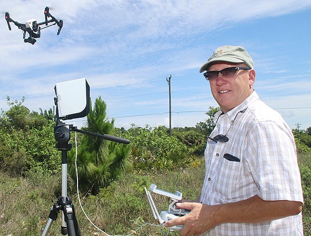
“The technology is really changing rapidly, and it's interesting how it's evolving,” says Jim Szabo, whose SanCap Aerial LLC has shot photographs and videos for commercial real estate firms and government agencies alike in Lee County. “Really, the possibilities are endless.”
And unlike aerial photography, the barrier to entry with drones can be relatively small. Szabo's first drone, for instance, cost just $700. Today, he flies a $6,000 DGI Inspire I UAV, with upgraded camera lenses and other capabilities. Measuring 28 inches across the wings, the drone weighs just more than seven pounds, he says.
To control the drone remotely, Szabo simply plugs it into an app on his iPad Mini.
“Drones are sweeping the commercial real estate industry at a staggering rate,” says Gary Tasman, chief executive of brokerage firm Cushman & Wakefield Commercial Property Southwest Florida, based in Fort Myers, who has used SanCap to shoot sites.
“They're faster, they're better at producing images and they're easier to change as the data or the property you want to shoot changes.”
Back in the olden days — say, 2002 — Tasman explains, a commercial real estate broker that needed an elevated photograph of a tract of land, a shopping center or an office building would have to hire an aerial photography company, which, in turn, would take its helicopter or plane out from an airport to a site designated on a map.
Once shot, the film would have to be processed and heavily edited for content. The process would often take days. And in the case of a retail center, if a major tenant left, the aerial data would be obsolete and have to be re-shot.
“It was both expensive and time consuming,” Tasman says.
Today, by contrast, smart mapping and satellite data allows drones to zero in on sites with precision and without the need of an airport. And because the material is all in a digital format, it can be more easily edited and transferred to the broker electronically — often the same day as the shoot.
Oh, and the cost? It's about one-tenth as much as traditional aerial photography. SanCap's packages, for instance, start at about $150 an hour.
Perhaps not surprisingly, traditional aerial photographers aren't thrilled with UAV competition — and note that drones have significant drawbacks.
“I'm not a big fan of drones,” says Detlev von Kessel, owner of Pix360, an aerial photography company based in Sarasota. “The liability is high, the maintenance costs are high, and the quality of the images often aren't better because of the lenses drones have.”
Von Kessel notes that in Sarasota, the location of the Sarasota-Bradenton International Airport at U.S. 41 and University Parkway means drone usage is prohibited in large swaths of the city, in Bradenton and Longboat Key.
For now, he says, he's sticking with his helicopter, which can hover as low as 30 feet off the ground and take better shots, thanks to zoom lenses.
Still, he acknowledges that he's lowered his prices in some cases to compete with drones, and is considering contracting out to make them available in some capacity for Pix360 customers.
But some commercial real estate practitioners say drones — in many geographic areas — have several advantages over traditional aerials.
“In bigger land areas, especially, drones are really good,” says Kirk Boylston, president of Lakewood Ranch Commercial, an affiliate of Schroeder-Manatee Ranch, the master developer of the Lakewood Ranch community that spans more than 31,000 acres in both Sarasota and Manatee counties.
“They allow you to take a lot more footage, and in areas where it would be difficult to get a helicopter into. With drones, there's no disturbance to neighbors and the video is typically better. We're shooting a lot more video now that we're employing drones.”
Most recently, Schroeder-Manatee has begun using drones to produce promotional material for its golf courses. With a drone, a golfer can see a hole from tee to cup before stepping on a course.
But it's not just developers and brokers who've gotten on board with UAV technology.
Engineers and architects alike are using drones to help calculate how buildings will fill sites and determine elevations. They're also using them to produce 3-D models of unbuilt buildings and to conduct surveys. In the past, surveyors would have to scan sites with handheld lasers and produce reams of data, which would then be turned into two-dimensional
sketches.
Today, thanks to drones and software packages like AutoCAD and Revit, engineers and architects can produce virtual reality imaging of what a project will look like and how it will occupy a site before the first grader shows up to clear dirt.
“Drones show a much better scope of a property, what's unique about it, the access points and other details,” says Ryan Sampson, principal at Eshenbaugh Land Co., a Tampa firm that often sells large agricultural tracts to developers.
“They tell a much better story than simply a picture shot by a camera from the side of a road.”
Eshenbaugh, which has been using drones for three years now, often embeds drone-captured videos into email blasts sent to prospective customers, Sampson says.
Szabo admits, however, that drones and their operators do have limitations.
Under Federal Aviation Administration rules, drones cannot fly higher than 400 feet, or faster than 40 miles per hour. They're restricted within five miles of airports, too, that have control towers or utilize instruments upon airplane approach.
Worse, many operators are unskilled hobbyists who break the law by flying their drones. Szabo, by contrast, is a licensed pilot who spent seven months getting a certification to fly drones from the FAA.
He envisions using software to augment his drone photography with thermal imaging, 3-D mapping and other specialties.
Tasman says even without those extra bells and whistles, drone-produced pictures and videos are allowing commercial real estate firms to be more collaborative with photographers and generate better materials.
“The flexibility and the real-time nature of the end product have really cut down on production times a lot,” Tasman says. “Now it's just a matter of how much creativity you can employ to help market your properties.”
- K.L. McQuaid